
Table of Contents
- The book at a glance
- Why this book matters for Atlantis research
- Preface: a treasure chamber
- Section One: The historical basis of the Atlantis legend (pp. 19 to 53)
- Solon in Sais, and fable or fact
- 8,000 months, not 8,000 years
- Contemporary texts: Medinet Habu and the Papyrus Harris
- The natural disasters around 1200 BC
- The military campaigns against Egypt and Greece
- Section Two: The home of the North Sea peoples and the site of Atlantis (pp. 57 to 137)
- Where the North Sea peoples came from
- Basileia at the Steingrund
- Orichalc as amber
- Heligoland copper
- Size and organisation of the empire
- Basileia, the holy island
- Who wrote the original report
- Section Three: Homer’s account of Atlantis-Basileia (pp. 141 to 175)
- Atlantis and the island of the Phaeacians
- Homer’s legends of the North Sea area
- The rediscovery of Atlantis: the dives of 1952 and 1953 (pp. 176 to 189)
- Epilogue (pp. 190 to 191)
- The appendix: Plato’s Atlantis report
- Reception: how scientists and supporters responded
- Where to read it
- FAQ
- Where did Jürgen Spanuth place Atlantis?
- When did Atlantis sink, according to Spanuth?
- Who were the Atlanteans, in his view?
- Why does Spanuth say orichalc was amber?
- Related on this site
- Sources
Most Atlantis books look west, into the open Atlantic. Jürgen Spanuth looked north. He was a Lutheran pastor in Bordelum, a village behind the dikes of the North Frisian coast in Germany. In 1953 he published a book that placed the royal island of Atlantis a few miles from Heligoland, the red rock island in the German Bight.
The English edition, Atlantis: The Mystery Unravelled (1956), builds the case in three parts: Egypt’s records of the northern invaders and the disasters around 1200 BC, then the North Sea coast and the royal island Basileia, then Homer’s Phaeacians as a memory of that island. A closing chapter tells how divers went down off Heligoland in 1952 and 1953, and a short epilogue sums up his picture of the end of the Bronze Age.
The book at a glance
- Original title: Das enträtselte Atlantis (“Atlantis Deciphered”), Union Deutsche Verlagsgesellschaft, Stuttgart, 1953.
- English edition: Atlantis: The Mystery Unravelled, first published in 1956 by Arco Publishers, London.
- American issue: Citadel Press, New York, 1956, printed as the “First American Edition”. The sheets were printed in Great Britain by the Garden City Press in Letchworth.
- Translator: not named anywhere in the book.
- Length: 207 pages, with maps, drawings and photographs, plus an appendix with Plato’s Atlantis passages.
- Author: Jürgen Spanuth (1907 to 1998), pastor of Bordelum from 1933 to 1977.
Why this book matters for Atlantis research
Spanuth’s thesis is simple to state. Atlantis was not an Ice Age continent in the Atlantic. It was the centre of the Nordic Bronze Age, a culture of northern Germany, Denmark and southern Scandinavia around 1700 to 500 BC. Its royal island, which Plato calls the island of the royal city, sank in storm floods around 1200 BC.
The survivors, in his view, became the “Sea Peoples”. These were the raiders who attacked Egypt and the eastern Mediterranean at the end of the Bronze Age. The Egyptians carved their wars into the walls of a temple at Medinet Habu.
The thesis matters because it connects three sources that are usually read apart: Plato’s Atlantis report, the Egyptian records of the Sea Peoples, and Homer’s island of the Phaeacians. It also names a real place where people can dive and test it.
For the full Plato text, see my page Timaeus & Critias. For other locations, see Where Was Atlantis.
Preface: a treasure chamber
Spanuth compares the Atlantis report with the tomb of Tutankhamun. Experts thought the Valley of the Kings was exhausted, until Lord Carnarvon’s dig found the tomb. The Atlantis report, he says, is also an unopened treasure chamber.
His method has two steps. First he puts the events of the report in their historical order. Then he tests each detail of the report against what archaeology knows about that time.
Section One: The historical basis of the Atlantis legend (pp. 19 to 53)
Solon in Sais, and fable or fact
Plato says Solon, the Athenian lawgiver, heard the story from priests in Sais, a city in the Nile delta, around 560 BC. Spanuth accepts this chain. For him the report is fact with a corrupted surface: some numbers went wrong on the way, but the core events are real.
8,000 months, not 8,000 years
Plato’s dates are the famous problem. The Egyptian priest says Sais was founded 8,000 years before Solon, and Athens 9,000 years before (Timaeus 23e). Critias says the war happened 9,000 years earlier. That would put Atlantis around 9600 BC.
Spanuth says this cannot be right. The Atlanteans in Plato use bronze, tin and copper. They have harbours, canals, chariots and warships. That fits the late Bronze Age, not the Old Stone Age.
Plato even gives a clue about iron. In the bull hunt of the ten kings, the kings hunt “with staves and nooses but with no weapon of iron” (Critias 119e, Bury translation on my Timaeus & Critias page). Spanuth reads this as a memory of the time when iron was known but still rare, which is the late 13th century BC.
He then takes up an idea from the Swedish scholar Olof Rudbeck (1630 to 1702):
"...we must think not of eight thousand years but of eight thousand months between the fall of Atlantis and Solon's stay in Egypt. If this is so, the fall of Atlantis must have taken place about 1200 B.C."
Spanuth, Atlantis: The Mystery Unravelled (1956), p. 27
His sum is short. 8,000 months of 12 to a year make about 666 years. Solon was in Egypt around 560 BC. 560 plus 666 gives about 1226 BC. In that same period, Libyans and their northern allies attacked Egypt under Pharaoh Merneptah.
The 8,000 and 9,000 question: The 1956 English edition uses 8,000 months, the age of Sais. Later summaries of his theory, such as the German Wikipedia article, use 9,000 lunar months instead. 9,000 lunar months are about 673 solar years, which lands near 1230 BC. Both versions give almost the same date. The difference matters only if you quote him.
Contemporary texts: Medinet Habu and the Papyrus Harris
Spanuth builds on Egyptian sources from around 1200 BC. The main ones are the texts of Pharaoh Merneptah and the temple of Ramses III at Medinet Habu, on the west bank at Thebes (modern Luxor). Its walls show the land and sea battles against the invaders. He also uses the Papyrus Harris, a long scroll in which Ramses III reports on his reign, and the Papyrus Ipuwer, a lament about disasters in Egypt. He adds Exodus as a further witness to the disasters.
The natural disasters around 1200 BC
Spanuth argues that the wars were set off by a chain of natural disasters. He splits them into two parts.
(a) Drought and fire. Egyptian texts speak of fire from the sky striking the Libyans. He links this to the Greek myth of Phaethon, who drove the sun chariot off course and set the earth on fire. The priest of Sais tells this myth to Solon in the Timaeus.
He also uses the German archaeologist Oscar Paret. Paret argued that the Bronze Age “lake dwellings” of central Europe were villages built on shores left dry by a drought, later flooded when the water rose. Paret dated the worst drought to around 1200 BC.
(b) Earthquakes and floods. On the west coast of Schleswig-Holstein, the sea cut cliffs and beach walls into the land. Spanuth notes that Iron Age finds occur there but Bronze Age finds do not, so he dates the cliffs to the disasters around 1200 BC. His key step follows. A large island near Heligoland had worked as a breakwater, and only when it sank could the sea attack the coast.
The military campaigns against Egypt and Greece
Spanuth retells the wars of the “North peoples”, as he calls the Sea Peoples.
First came the attack on Egypt under Merneptah. In his fifth year, which Spanuth dates to 1227 BC, Merneptah defeated the Libyans and their allies at Perire in the western Delta. The northern allies fought on the Libyan side.
Then came the great invasion under Ramses III, which Spanuth dates to 1195 BC. The Medinet Habu reliefs show ox carts with women and children, a sea battle in which the northern ships are capsized, and prisoners branded with the king’s name.
Before that, he says, the North peoples came south through Greece and destroyed the Mycenaean palaces, while the Athenians held out on the Acropolis. For Spanuth, that is the core of Plato’s claim that Athens alone resisted Atlantis.
Section Two: The home of the North Sea peoples and the site of Atlantis (pp. 57 to 137)
Where the North Sea peoples came from
Plato says Atlantis lay in the outer ocean, beyond the Pillars of Heracles. Spanuth reads one Greek word in the report as “towards the north wind”. He concludes:
"We must therefore place Atlantis to the north of Egypt and Greece in the World Ocean, as is said in the Atlantis report."
Spanuth, p. 58
The Egyptians imagined a “Great Water Circle”, an ocean that runs around the inhabited world. Spanuth says the invaders came from islands in this outer ocean.
"In the inscriptions of Medinet Habu and in the Papyrus Harris it is said that the North people came from the end of the earth, or from the 'great darkness.'"
Spanuth, p. 59
Next he compares the gear of the Sea Peoples with Nordic Bronze Age finds. Their long swords, he says, match northern tanged swords of around 1200 BC. A tanged sword has a flat strip of metal, the tang, that runs into the handle. Their horned helmets and their ships, with tall stems ending in a swan or dragon head, also have northern parallels, for example in Swedish rock carvings.
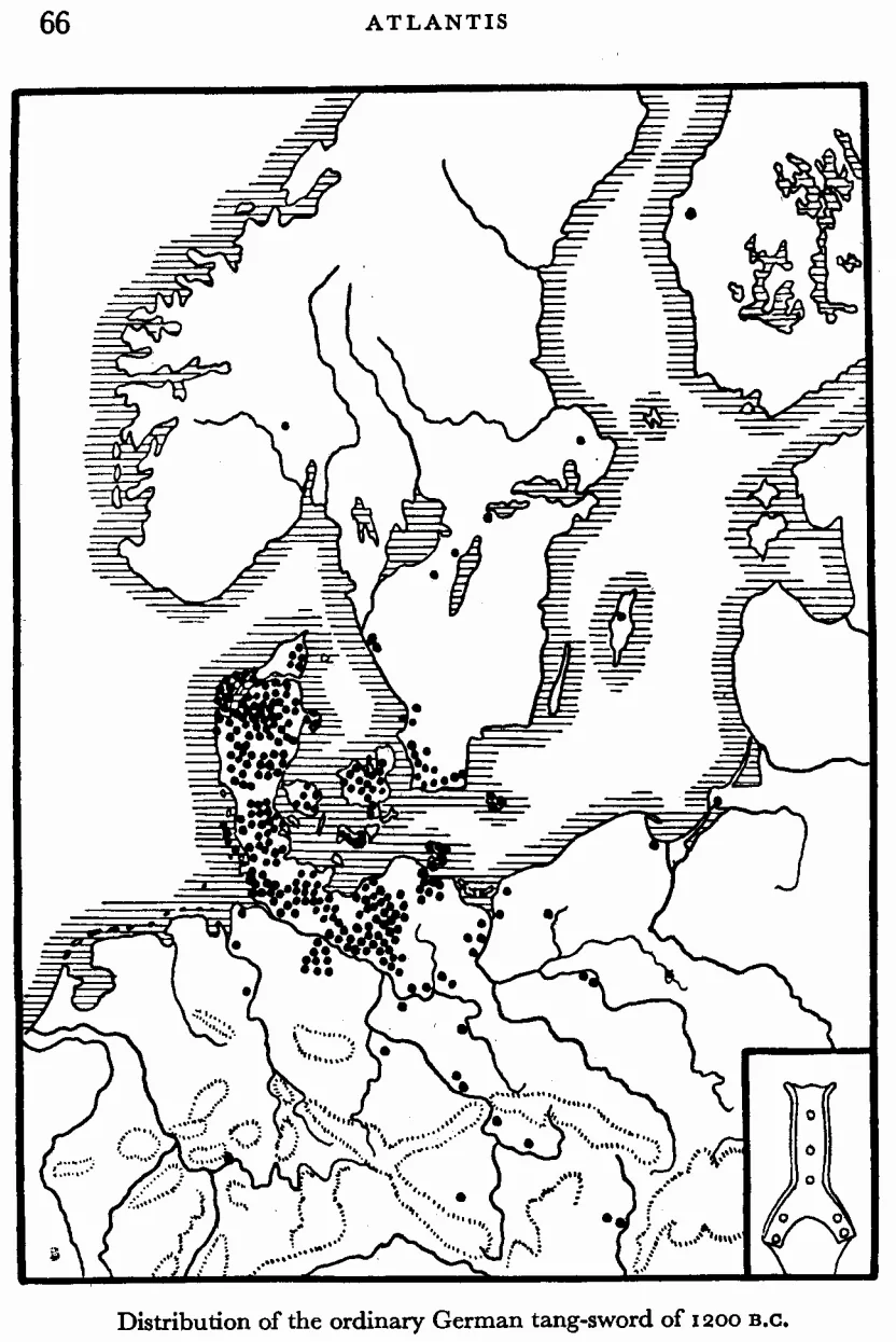
Jürgen Spanuth, Atlantis: The Mystery Unravelled (1956), page 66.
Basileia at the Steingrund
Now comes the heart of the book. Spanuth looks for the royal island at a precise spot. Plato describes red, white and black stone on the island. Heligoland has red sandstone, white chalk and dark rock. So, for Spanuth, Heligoland is the rock island in front of the royal island, and the royal island must lie nearby.
He uses Pytheas of Massalia, a Greek explorer who sailed north in the 4th century BC. Pytheas’s report is lost. Later writers such as Diodorus and Pliny quote it. They mention an island called Basileia, Greek for “royal”, where amber washes ashore. The amber was carried there by the river Eridanus. Spanuth identifies the Eridanus with the Eider, a river of Schleswig-Holstein that still carries amber near its mouth.
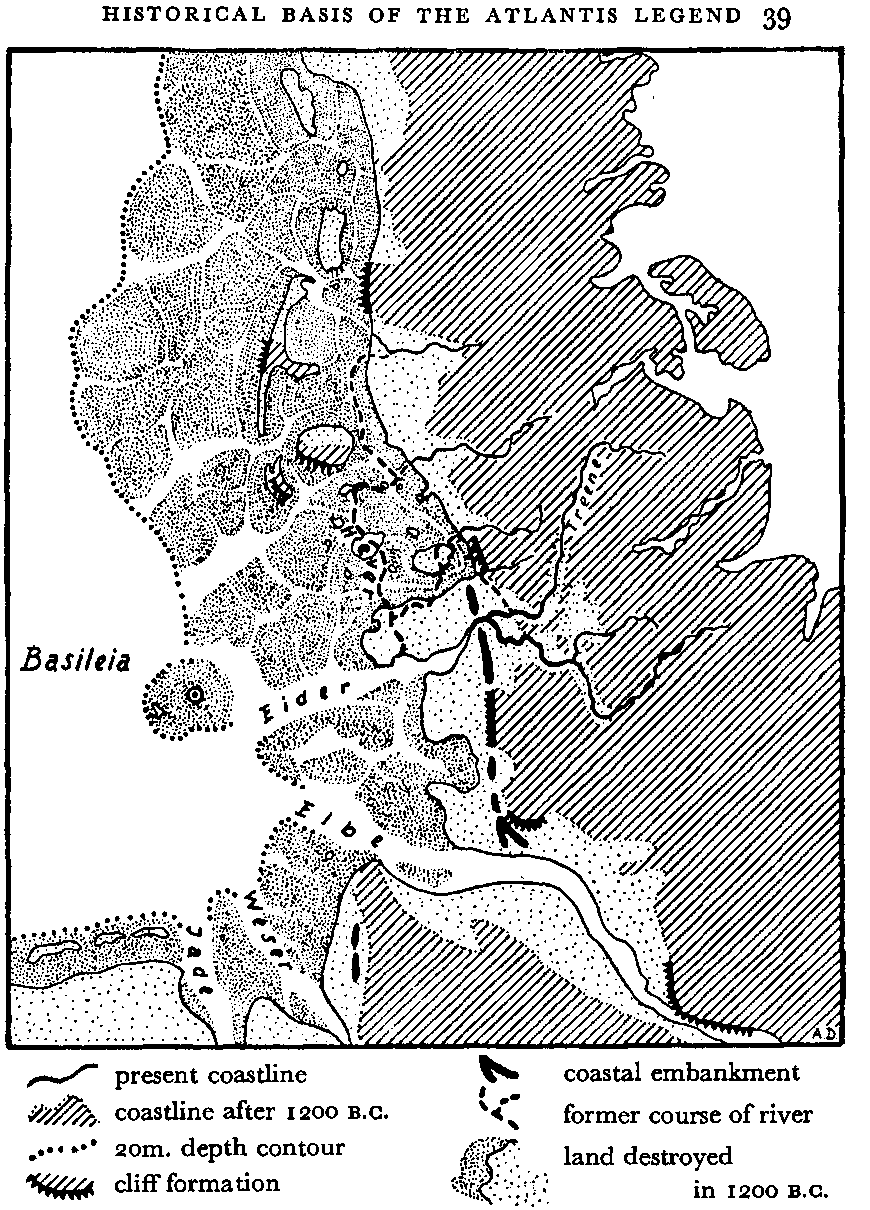
Jürgen Spanuth, Atlantis: The Mystery Unravelled (1956), page 39.
Amber does not occur in the Heligoland rock. So the amber island Basileia must have lain between Heligoland and the Eider mouth. And there, east of Heligoland, a low hill rises from the sea floor:
"This hill is strewn with large stones and is therefore called 'Stoneground' (Steingrund)."
Spanuth, p. 83
An old Heligoland legend, he says, places a temple and a castle on this spot. He draws his conclusion directly:
"According to the Atlantis report this must be the spot where stood the royal castle and the temple of Poseidon."
Spanuth, pp. 83 to 84
Plato’s own words fit the shape. In the Critias, the hill of Cleito, where the royal city later stood, was “a mountain that was low on all sides” (Critias 113c, Bury, on my Timaeus & Critias page). Plato also says that after the island sank, “the sea in those parts is impassable and impenetrable, because there is a shoal of mud in the way” (Timaeus 25d). Spanuth points to the Wadden Sea, the wide tidal mudflats of the German and Danish coast, as that “sea of mud”.
He also uses old maps of Heligoland, including one from around 1570 and one by the cartographer Johannes Meyer from around 1650. These maps show land and old sites east of today’s island.
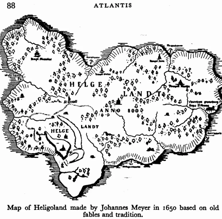
Jürgen Spanuth, Atlantis: The Mystery Unravelled (1956), page 88.
A simple sketch of his geography, not to scale:
            NORTH SEA
                 |
   Heligoland (red, white, black rock)
                 |
         about 6 miles east
                 |
   Steingrund  =  Basileia, the royal island (sunk c. 1200 BC)
                 |
     Wadden Sea mudflats  =  Plato's "shoal of mud"
                 |
   Eider mouth  =  the amber river Eridanus
                 |
   Schleswig-Holstein coast (Bordelum, Husum)
Orichalc as amber
Plato says the Atlanteans prized a metal called orichalc (Greek oreichalkos, “mountain copper”). Plato’s text, in Bury’s translation, calls it “the most precious of the metals then known, except gold” (Critias 114e). Plato also says it was mined in many places and covered the walls of the citadel with a fiery shine.
Spanuth proposes that orichalc was not a metal at all:
"The orichalc of the Atlantis report could only mean amber, and we shall therefore translate the word orichalc with amber."
Spanuth, p. 92
His reasons: amber was valued next to gold in the Bronze Age, it was dug from the ground on the North Sea coast, it glows like fire, and it was traded as far as Mycenae and Egypt.
Heligoland copper
Plato says Atlantis had copper. Spanuth says Heligoland had copper too, and very pure copper.
"Spectro-analytical investigations of solid copper pieces from Heligoland have shown that it was extremely pure copper."
Spanuth, p. 95
He argues that the Northmen of the Bronze Age could work this copper. He also discusses gold, silver, tin and iron in the Atlantean economy.
Size and organisation of the empire
Plato describes ten kings ruling ten parts of the realm. Spanuth maps this onto the whole Nordic Bronze Age area, with Basileia as its centre. He pictures Basileia as a great harbour at the mouths of the Weser, Elbe and Eider, doing the work later done by Bremen, Hamburg and Lübeck.
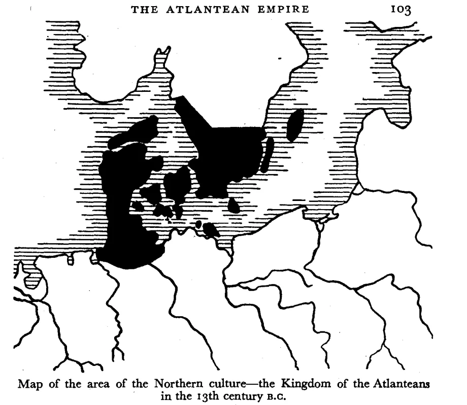
Jürgen Spanuth, Atlantis: The Mystery Unravelled (1956), page 103.
Basileia, the holy island
Spanuth reads the religious details in Plato as northern customs. Plato’s rings of land and water become a “Trojan castle”, a hill ringed by concentric walls or stone circles, a type of sun sanctuary he finds across northern Europe. The pillar of laws in the temple becomes the northern world pillar that holds up the sky, the Irminsul of Saxon tradition. He adds the bull sacrifice, a fire cult, the king’s blue robe and the temple of Poseidon. Then he reaches the wall:
"On July 31st, 1952, this great wall was discovered at the stated spot, six miles from Heligoland towards the mainland."
Spanuth, p. 108
Who wrote the original report
Spanuth closes Section Two by arguing that the original report was an Egyptian record of the war with the North peoples, written around 1200 BC and later told to Solon. Words passed from the Atlantean language into Egyptian and then Greek, which he says explains errors such as “orichalc” for amber. He also reviews earlier attempts to locate Atlantis.
Section Three: Homer’s account of Atlantis-Basileia (pp. 141 to 175)
Atlantis and the island of the Phaeacians
In Homer’s Odyssey, Odysseus washes ashore on Scheria, the island of the Phaeacians. The Phaeacians are great sailors with a royal city, a harbour and a temple of Poseidon. Rudbeck, Ignatius Donnelly, Adolf Schulten and Richard Hennig had already noticed that Scheria looks like Atlantis.
Spanuth sets out a two-column list of 32 parallels. Both islands lie in the ocean. Both are ruled by descendants of Poseidon. Both have bull sacrifices, ship sheds, a mild climate and two harvests a year. His conclusion is direct:
"This parallel survey shows clearly that Atlantis and the land of the Phaeacians were identical."
Spanuth, p. 146
He argues that Homer did not copy Plato. Homer lived centuries earlier and adds details that Plato lacks. So both, he says, drew on one memory of a real island.
He also reads Homer’s sailing directions to Scheria as a route to the North Sea.
Homer’s legends of the North Sea area
Spanuth finds more northern memories in the Odyssey. Among them are the ferrymen of the dead, and the Laestrygonians, whose nights are so short that one herdsman driving his flock in meets another driving his out. He reads this as the summer nights of the far north. He also places the misty land of the Cimmerians in the north.
The rediscovery of Atlantis: the dives of 1952 and 1953 (pp. 176 to 189)
This chapter reads like an adventure story. Spanuth says that by 1948 he was convinced that Basileia lay about six miles east of Heligoland. He bought a sea chart to see what lay there.
"I shall never forget the moment when I unrolled the sea map."
Spanuth, p. 176
The chart showed a low hill with fields of stones at the exact spot. Experts told him the stones were natural moraine, a mound of rock and gravel left by an Ice Age glacier.
In the summer of 1952, after Britain returned Heligoland to Germany, he hired a boat and a diver. The diver was Herbert Beelte, spelled “Belte” in the book. On 31 July 1952 Beelte reported walls on the sea floor. TIME magazine covered the expedition on 8 September 1952. It reported a wall that enclosed an oval area about 1,000 yards long.
In July and August 1953 a second expedition followed with the diver Eberhard Fries. Fries made 27 dives. Spanuth dived himself. They report ramparts, gaps in the ramparts, paved surfaces and flat flint slabs. Spanuth also used echo-sounder records from a survey ship. An echo sounder maps the sea floor with sound pulses.
"All agree that the ramparts, rampart gaps, cobbled streets and the places covered with tiles were not formed by natural means, but must surely have been created by the hands of men."
Spanuth, p. 189
Epilogue (pp. 190 to 191)
The epilogue returns to the treasure chamber image. Spanuth sums up his picture of the end of the Bronze Age:
"...the gigantic regroupings of population were caused during the last third of the thirteenth century B.C. by world-wide natural catastrophes..."
Spanuth, p. 190
In his view, the peoples from the north swept through Europe and Asia Minor to Egypt. They destroyed old cultures, but they also laid the ground for classical Greece. He also connects the North peoples with the Philistines of the Bible.
The appendix: Plato’s Atlantis report
The book ends with an English version of Plato’s two Atlantis passages, from the Timaeus and the Critias. It is useful as a reference, but it is not the best translation to read today.
I recommend reading Plato directly in R. G. Bury’s public-domain translation on my page Timaeus & Critias. For a guided summary of the Critias, see Critias, the story of Atlantis.
Reception: how scientists and supporters responded
The book caused a storm in Germany. In 1953 Karl Gripp, head of the Geological Institute at the University of Kiel, invited Spanuth to a public debate. Twelve specialists from different fields took part. According to Die Zeit (no. 46, 1953), all of them rejected his thesis.
The critics published a book in the same year, edited by the geologist Richard Weyl: Atlantis enträtselt? Wissenschaftler nehmen Stellung zu Jürgen Spanuths Atlantis-Hypothese (Kiel, 1953). Gripp followed with an article in 1954. Spanuth answered in 1955 with …und doch: Atlantis enträtselt! (“…and yet: Atlantis deciphered!”).
The website Atlantipedia, citing the author Felix Paturi, reports a legal sequel. After critics called Spanuth a liar, he took them to court. According to that account, ten professors withdrew their claims after about six years.
Later research raised several specific objections. The German Wikipedia article on Spanuth summarises them, with sources:
- The Steingrund. It is now described as a natural, crescent-shaped reef of Ice Age moraine material. It is a protected nature area.
- Thera. In later books, Spanuth linked the disaster to the eruption of Thera (Santorini). That eruption is now dated to around 1600 BC, centuries before the Sea Peoples.
- The swords. The tanged swords of the type called Naue II first appear in northern Italy, not in the north (Robert Drews, The End of the Bronze Age, 1993).
- Heligoland copper. No known Bronze Age object has been traced to Heligoland copper. The copper ingots found off Heligoland date from the Middle Ages.
- The Philistines. Many archaeologists now link them to the Aegean world, for example Assaf Yasur-Landau (2010).
- Ipuwer. The papyrus is usually dated to well before 1200 BC.
Spanuth also had supporters and forerunners. Olof Rudbeck had already put Atlantis in the north in the 17th century. Wilhelm Christ suggested in 1886 that the Sea Peoples were the Atlanteans. Richard Hennig compared Atlantis and Scheria in 1926. Among later writers, Günther Kehnscherper (1978), Walter Stender, Arn Strohmeyer and Felix Paturi (2007) defended parts of the thesis. The ethnologist Hans Peter Duerr thanked Spanuth in his book on the sunken North Sea town of Rungholt (2005).
Separate from the geography thesis, the historical record shows that Spanuth joined the NSDAP in 1931 and served in the SA from 1933 to 1938, and that his later books appeared with far-right publishers such as Grabert, where his work was read as “Atlanteans = Germans” (German Wikipedia, citing Bundesarchiv and Schleswig-Holstein church records).
Where to read it
The book is out of print and still under copyright, so I do not reproduce it here. These library records are legal places to find or search it:
- HathiTrust, English 1956 edition (Arco): catalog record 001879883. Search only, no full view.
- HathiTrust, German 1953 original: catalog record 001275635. Search only.
- Google Books, Arco 1956 edition (listed under the misspelled title “Atlantic, the Mystery Unravelled”): record. No full view.
- Open Library, Citadel 1956 edition: record with links to nearby libraries.
His later books can be borrowed legally from the Internet Archive lending library:
- Atlantis of the North (1979 and 1980), the English version of Die Atlanter: archive.org/details/atlantisofnorth00span
- Atlantis: Heimat, Reich und Schicksal der Germanen (1965): archive.org/details/atlantisheimatre0000span
- Die Philister (1980): archive.org/details/diephilisterdunb0000span
FAQ
Where did Jürgen Spanuth place Atlantis?
He placed the royal island, Basileia, at the Steingrund, an underwater stony hill about six miles east of Heligoland in the German North Sea. He saw the whole Nordic Bronze Age realm as the kingdom of Atlantis.
When did Atlantis sink, according to Spanuth?
Around 1200 BC. He read Plato’s “8,000 years” as 8,000 months, which gives about 1226 BC. He linked the sinking to droughts, fires, earthquakes and storm floods at the end of the Bronze Age.
Who were the Atlanteans, in his view?
The people of the Nordic Bronze Age. After the disaster, he says, they migrated south and appear in Egyptian records as the Sea Peoples.
Why does Spanuth say orichalc was amber?
He argues that only amber fits Plato’s description in a North Sea setting: precious next to gold, dug from the ground and shining like fire. He treats “orichalc” as a mistranslation on the way from Egypt to Greece.
Related on this site
- Where Was Atlantis: other proposed locations.
- The Sea Peoples and the Philistines: who the Sea Peoples were.
- Orichalcum: the mysterious metal of Atlantis.
- The Phaeacians and Phoenicians: Homer’s island people.
- Critias, the story of Atlantis: Plato’s description of the island.
- The Oera Linda Book Reviewed: the Frisian chronicle of a sunken Atland, with its dates counted two ways.
You may also like The Oera Linda Book, which describes a lost land west of Jutland with Heligoland as one of its remnants.
Sources
The book
- Jürgen Spanuth, Atlantis: The Mystery Unravelled, Arco Publishers, London, and Citadel Press, New York, 1956. Translated from Das enträtselte Atlantis, Union Deutsche Verlagsgesellschaft, Stuttgart, 1953. Page numbers above refer to the 1956 edition.
Plato (public domain)
- Plato, Timaeus 23e, 25d and Critias 113c, 114e, 119e, translated by R. G. Bury (Loeb, 1929). Text on Timaeus & Critias.
Reception and background
- “Jürgen Spanuth”, German Wikipedia (biography, reception, objections, NSDAP and SA records citing the Bundesarchiv). de.wikipedia.org
- “Atlantisschlacht der Gelehrten”, Die Zeit, no. 46, 1953 (the Kiel debate), as cited by German Wikipedia.
- Richard Weyl (ed.), Atlantis enträtselt? Wissenschaftler nehmen Stellung zu Jürgen Spanuths Atlantis-Hypothese, Mühlau, Kiel, 1953.
- Jürgen Spanuth, …und doch: Atlantis enträtselt! Eine Entgegnung, Stuttgart, 1955.
- “Science: Sunken City”, TIME, 8 September 1952. time.com
- Atlantisforschung.de, “Spanuths ‘Steingrund’-Expeditionen und die Diskussion ihrer Ergebnisse” (diver Herbert Beelte, 31 July 1952). atlantisforschung.de
- Atlantipedia, “Spanuth, Dr Jürgen” (court case, citing Felix R. Paturi). atlantipedia.ie
- Robert Drews, The End of the Bronze Age: Changes in Warfare and the Catastrophe ca. 1200 B.C., Princeton University Press, 1993.
- Assaf Yasur-Landau, The Philistines and Aegean Migration at the End of the Late Bronze Age, Cambridge University Press, 2010.
- Eric H. Cline, 1177 B.C.: The Year Civilization Collapsed, Princeton University Press, 2014.


Comments are closed.