
Table of Contents
- Overview
- Key Locations and Events
- Geography of Oera Linda
- Section 13i: “Along the Rhine”
- Shifting Geography
- Coastal Changes and Flooding
- Place Name Migration
- Examples of Name Reuse
- The Aldera and Its Significance
- Description in Oera Linda
- Speculated Locations
- Challenges in Interpretation
- Archaeological and Geological Evidence
- Interdisciplinary Study
- Conclusion
Overview
The discussion focuses on the geographical changes and historical shifts associated with locations mentioned in the Oera Linda text. The conversation includes analysis of shifting coastlines, place name migrations, and their implications for understanding historical geography in the region known today as the Netherlands.
Key Locations and Events
Geography of Oera Linda
The geographical scope of the Oera Linda text spans a wide area, including the North Sea, the Netherlands, the Mediterranean, and India. The most detailed descriptions focus on “Frya’s Land,” corresponding to regions in the present-day Netherlands.
Section 13i: “Along the Rhine”
Key locations introduced in Section 13i of the text include:
- Aldera and the Aldera Mouth
- Treasureburg
- Burg Fana
- The Flea Lake and Flea Stream
- Alarum
Descriptions often include waterways, settlements, and strategic sites. Not all of these locations align precisely with modern geography due to natural and anthropogenic changes over centuries.
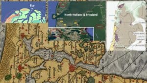
Shifting Geography
Coastal Changes and Flooding
The coastline and inland lakes described in the Oera Linda have undergone significant alterations. For example:
- The Flea Lake (Fleamar), now the IJsselmeer, was a smaller body of water historically.
- Flood events, such as those in West Friesland, reshaped the region, creating new lakes and submerging former settlements.
Place Name Migration
Several historical place names may have migrated over time due to:
- Flooding and relocation of communities, where new settlements adopted the names of lost ones.
- Enemy conquests, where names were changed or reused for new sites.
Examples include:
- Maidenblick (modern Medemblik) and Stavoren: The historical descriptions do not match their current locations, suggesting possible migration or reidentification.
- Frona (modern Groningen): Likely relocated and renamed following conquests.
Examples of Name Reuse
Historical and contemporary examples of reused place names include:
- New Amsterdam/New York in the Americas.
- New Zealand, named after the Dutch province Zeeland.
- Similarities between Dutch and Greek place names, such as Tessel and Thessaloniki.
These examples demonstrate how historical migration patterns influenced place naming conventions.
The Aldera and Its Significance
Description in Oera Linda
The Aldera is described as a lake surrounded by settlements, gardens, and barns. It was connected to the sea by a canal, making it a key passage for ships.
Speculated Locations
The Aldera Mouth and its associated structures are speculated to correspond with:
- Muiden: Identified as a strategic harbor for ships entering from the Flea Lake.
- The canal connecting to the North Sea, hypothesized to pass through what is now Amsterdam.
Maps from the 16th century and Roman-period archaeological sites suggest the Aldera region held significant strategic and economic importance.
Challenges in Interpretation
Archaeological and Geological Evidence
The interpretation of Oera Linda’s geography faces challenges due to:
- Continuous changes in the landscape from natural events.
- Limited archaeological data aligning directly with the descriptions in the text.
- Potential biases or inaccuracies in historical records and place names.
Interdisciplinary Study
A clearer understanding of the geography will require contributions from geology, linguistics, and archaeology. Analysis of sediment layers and ancient waterways may provide further insights.
Conclusion
The analysis of the shifting geography in Oera Linda reveals a complex interplay between natural and human factors over centuries. While some locations are identifiable, others remain speculative. Further interdisciplinary research is essential to advance understanding of the historical and geographical context of the text.
The discussion continues in forums where participants contribute maps, linguistic analyses, and interpretations. Viewers and researchers are encouraged to share their insights to build a more comprehensive understanding of the geography described in Oera Linda.
Comments are closed.